An official website of the United States government.
Here's how you know.
Official websites use .gov
A .gov website belongs to an official government organization in the United States.
Secure .gov websites use HTTPS
A lock () or https://means you've safely connected to the .gov website. Share sensitive information only on official, secure websites.
WildFireSA Release Notes
This next-generation application is packed with enhanced tools for wildfire situational awareness and response, and introduces new features designed to improve user experience and access to real-time data.
- WildFireSA – https://egp.wildfire.gov/maps – EGP WildFireSA is the publicly available version streamlined for the not logged in, at-a-glance, quick view.
- 🔥WildFireSA Advanced – https://egp.wildfire.gov/sa – EGP WildFireSA Advanced is designed for the longer session to understand initial attack emerging details, overall region metrics, and provide the broader common operating picture with near-real-time data.
🔥= Features in WildFireSA Advanced Only
Version 2.1.9 – April 22nd, 2026
EGP Data Service Updates
- DART Personnel/WFTAK Service updated; On 4/22/26 the NIFC Org will release Location Sharing for use within ArcGIS Field Maps to all basic field users, of which there are over 34,000. These users will not notice any changes beyond seeing this new option appear. This post covers what GISS/Power Users need to know and what field users will see in the Field Maps app. For additional details please see the DART Hub.
- The EGP WildFireSA Advanced viewer now includes a Resource Locations widget and the WildfireSA Advanced Web Map is now available to all users in Field Maps.
- Pop-up shows device information such as battery, speed, heading/direction
- Symbology shows direction traveling if available
- Updated to point to new service powered by faster updates
- Supports displaying data provided by new NIFC AGOL Survey123 form
- Resource Tracking panel updated to reflect the new service
- WildFireSA Advanced Web Map Visualization Improvements to Satellite Heat Detections for Hawkeye similar to MODIS and VIIRS last release to reduce lower confidence heat detection points
- Small scale / national: (Country to Counties) Confidence ≥ 80, symbols within 24 hours
- Medium scale / regional (Counties to Cities) Regional scale: Confidence ≥ 70, symbols within 24 hours
- Large scale / local (Cities and below) Local scale: Confidence ≥ 30
- WildFireSA Advanced Web Map Minor User Feedback Cartography updates:
- NIFS Event Points for Hydrants reduced in size from 26px to 18px
- Values At Risk available one zoom level smaller when imagery turns on
- Prescribed fires available one zoom level larger to reduce clutter
- For NWS SPOT Weather
- Added detailed Report link for quick access and cleaned up Pop-Up
- Added filter per NWS guidance.
- Available in the EGP Service Hub or Add Data in WildFireSA Advanced,
Feature Updates
- Added a link in WildFireSA Advanced in the Resources section to “WildFireSA Demo Video” available on the EGP Portal.
- Lightning export file now includes date time stamp
- EGP Active Incidents Panel now supports viewing Wildland Fire Complexes. Additionally, child incidents of a parent Complex will have a pink badge that allows users to quickly identify a child incident.
WildFireSA Coming Soon
- AFF aerial wildfire flight locations within WFSA Resource Tracking (Summer 2026)
- New service for IRWIN Non-statistical fires which are fires before a SIT-209 approved report. It represents the identified locations of events with sustained combustion that posed a threat to nearby wildland fuels but did not ignite them. These will provide information to support law enforcement and fire prevention use cases.
- New GOES Heat Detection service which will include quality control procedure to discard detections associated with industrial activity (ex., steel mills, gas flares, power plants) as well as potential false alarms caused by solar panels and other highly reflective surfaces, while also correcting for potential omission errors in the automated satellite fire products.
- Semi-Annual release on mobile and performance improvements
Version 2.1.8 – April 8th, 2026
EGP Data Service Updates
- EGP Active Incidents improvements and added support for:
- Complex (CX) data will be ingested for future use in the incident information panel.
- Added Perimeter burned Area to provide the most up-to-date acres burned data. This comes from WFIGS/NIFS Perimeter data which is updated more often and has more accurate and up-to-date acreage data compared to IRWIN.
- Recently released improved logic for validating incidents shown within each layer.
- Active Wildfires layer now only shows incidents with an acreage count > 0.1 acres.
- Primary WildFireSA Public and Advanced Web Map Visualization Improvements to Satellite Heat Detections for MODIS and VIIRS to reduce lower confidence heat detection points:
- Small scale / national (Country to Counties):
- VIIRS = show only symbols up to 24 hours, Night only, confidence nominal or High
- MODIS = confidence is at least 80, show only symbols up to 24 hours, Night only
- Medium scale / regional (Counties to Cities):
- VIIRS = show only symbols up to 24 hours, confidence nominal or High
- MODIS = confidence is at least 70, show only symbols up to 24 hours
- Large scale / local (Cities and below):
- VIIRS = confidence nominal or High
- MODIS = confidence is at least 30
- Small scale / national (Country to Counties):
WildFireSA Feature Updates
- Incident Panel Containment and Acres colors adjusted based on metrics to better reflect severity of both.
- 3D button available only at more zoomed in levels to reflect use case needs at more zoomed in and also improve performance.
WildFireSA Bug Fixes
- Stability Improvements to Mobile and smaller resolution screens for:
- Measurement tools (e.g. Pin Drop, Line and Area Measurement)
- Pop-Up and overall drawer responsiveness
WildFireSA Coming Soon
- AFF aerial wildfire flight locations within WFSA Resource Tracking (Summer 2026).
- New service for IRWIN Non-statistical fires which are fires before a SIT-209 approved report. It represents the identified locations of events with sustained combustion that posed a threat to nearby wildland fuels but did not ignite them. These will provide information to support law enforcement and fire prevention use cases.
- Even more up-to-date Resource Tracking Services for personnel.
Version 2.1.7 – March 10th, 2026
EGP Data Service Updates
- Updated EGP Active Incidents (Public Version - Advanced Version) Details and Services – Improved Active Incidents Service to improve synchronization between IRWIN, WFIGS, and SIT-209 with WildFireSA and NIFC.
- This creates a simplified integrated single incident points service, which combines Large Incidents, Active Incidents, Emerging Incidents, and Prescribed Fires into 1 service.
- Changes from Previous to EGP Active Incidents:
- Active and Active Large Wildfires have improved fall-off rules clearly described in the service (Public Version).
- Emerging Fires previously had 2 options and now there is only 1 option for less than 24 hours.
- Prescribed Fires were not previously included. Now they are and a user can turn them on/off.
- There are additional fields and improved grouping of fields in the App Incident Details and Pop-Ups.
- Contained fires will show until marked fully controlled in WFIGS.
- This will improve the synchronization of acreage, timestamps, and attribute updates for all incidents.
- 🔥 In WildFireSA Advanced, under Airborne Intel, IAA Requests for Missions and NIROPS has been updated to 2026 data.
WildFireSA Feature Updates
- Updated Incidents Panel in App for new service – The Incident Panels Details reflects the new fields in the updated EGP active incident service fields.
- Updated Metrics Panel in App for new service – Incident Metrics will reflect the EGP Incidents summary roll-up with links to the IMSR site to lower synchronization confusion and challenges.
- Added layer data download support – Users can now download layer data directly from the Data Catalog and ArcGIS Online tabs in a variety of formats (CSV, Shapefile, GeoJSON, KML, and more), with an option to filter by map extent. The Lightning data download feature has also been updated to leverage this new download infrastructure, including support for toggling applied data filters on or off before downloading.
WildFireSA Bug Fixes
- Added a popup notification to notify users which layers could not be added to the Maps if there is an error on load.
- Fixed application redirect bug from legacy URLs to new URLs.
- Print Workaround – Improved print stability based on ESRI bug.
WildFireSA Coming Soon
AFF aerial wildfire flight locations within WFSA Resource Tracking – Moved to Version 2.1.8 Coming Soon
Version 2.1.6 – February 25th, 2026
EGP Data Service Updates
- Added 7-14 Days Lightning to the EGP WildFireSA Data Services Hub and WildFireSA Advanced Web Map
WildFireSA Feature Updates
- Search Update – Added RAWS Weather Stations to the feature quick search capability. The Search Capability currently also supports:
- Address
- Geo-coded businesses, landmarks, and other points of interest
- EGP Active Incidents
- Coordinates (e.g. in decimal [e.g. 39.3346, -105.8156] or DMS [e.g. 34° 37' 60" N, 105° 12' 2" W])
- Apparatus/Vehicle Hood Codes (WildFireSA Advanced only)
- Active Incidents Panel Update – Added new active incident filters for Cause and Landowner
- Lightning Panel Update – Added a new lightning layer toggle button for the "7-14 Days" sublayer
- New Resources Tracking Panel that will allow users to be able to see statistics on Vehicles and Personnel at a national and nearby level
- A new "Resources" tab has been added to the incident detail view that will show resources in the proximity of the incident.
WildFireSA Bug Fixes
- Added ArcGIS Online support for map presets that contain personal layers
WildFireSA Coming Soon
Updated Incidents Details and Services – Delivered in Version 2.1.7**Print Workaround – Delivered in Version 2.1.7- NIFS IR Heat Detection Polygons will be updated for 2026 to replace the 2025 layer
Support for additional download formats in the Lightning Strikes component – Delivered in Version 2.1.7AFF aerial wildfire flight locations within WFSA Resource Tracking – Delivered in Version 2.1.7New Data Download Panel – Delivered in Version 2.1.7
Version 2.1.5 – February 12th, 2026
EGP Data Service Updates
- Added FireWise Communities (NFPA) to EGP WildFireSA Data Services Hub
- In preparation for the new Incident Details Service next sprint, minor web map updates
- Under Wildfire Incidents, Incident Points and Incident Perimeters sub-groups have been removed. As well, the Web Map will use the National GACC Boundaries Public for display and no longer use the EGP roll-up aggregated service. As well EGP WildFireSA Data Services Hub home page is now updated to point to new Incident metrics services.
- All saved map presets will automatically update based on these changes.
WildFireSA Feature Updates
- Improved IFrame support for mobile and desktop for embed on other web sites
WildFireSA Bug Fixes
- Fixed an issue where the Layer List Widget showed opacity controls for layers that can't change opacity.
- Fixed an authentication issue that was stopping layers from being added from the ArcGIS Online tab.
WildFireSA Coming Soon
- Updated Incidents Details and Services – Improved Active Incidents Service to improve synchronization between IRWIN, WFIGS, and SIT-209 with WildFireSA and NIFC.
- This creates a simplified integrated single incident points service which combines Large Incidents, Active Incidents, Emerging Incidents, Prescribed Fires into 1 service.
- This will improve the synchronization of acreage, timestamps, and attribute updates for all incidents.
- This will also improve attributes on the incident details panel and pop-up.
- Incident Metrics will reflect the EGP Incidents summary roll-up with links to the IMSR site to lower synchronization confusion and challenges.
- New Resources Tracking Widget that will allow users to be able to see statistics on Apparatus and Personnel at a national and nearby level
- Support for additional download formats in the Lightning Strikes component
- AFF aerial wildfire flight locations within WFSA
Version 2.1.4 – January 28th, 2026
EGP Data Service Updates
- NIFS Services updated in web map – Annually, NIFC updates the NIFS Services. The NIFS Current year has been added to the WildFireSA Advanced webmap. The NIFS Previous year will show through March 2026 and will be removed thereafter.
- Jurisdictional Units Public field pop-ups have been updated to reflect NIFC changes in 2026.
WildFireSA Feature Updates
- Improved Map Preset change support for WildFireSA when the web map has name and alias changes to limit or not impact saved map presets.
- Validation that FAMAuth has fixed the limited session issue back to maximum allowed by Security (12 hours)
- Updated the result count text across all paginated lists to improve clarity.
WildFireSA Bug Fixes
- Airborne Imagery and Video Pop-Up link fix for expired tokens for images and videos. This impacted the pop-ups only.
- Print Performance/Stability Workaround – ESRI has a known bug (ESRI BUG-000174933) for printing/generating PDF/file with clustered symbols which breaks print when Resource Tracking and Airborne Intel Mapping is turned on.
- Until fixed, turn off the Groups Resources Tracking and Airborne Intel Mapping prior to printing/generating a PDF/file. These services use the Cluster capability at medium scale and as zoomed in, shows the individual apparatus or personnel. Even when zoomed in and not clustered, the bug prevents a successful print/generation of a PDF/file.
WildFireSA Coming Soon
- Updated Incidents Details and Services – Improved Active Incidents Service to improve synchronization between IRWIN, WFIGS, and SIT-209. WildFireSA and NIFC This creates a simplified integrated single incident points service which combines Large Incidents, Active Incidents, Emerging Incidents, Prescribed Fires into 1 service. This will improve the synchronization of acreage, timestamps, and attribute updates for all incidents. This will also means improved attributes on the incident details panel and pop-up.
- New Resources Tracking Widget that will allow users to be able to see statistics on Apparatus and Personnel at a national and nearby level
- Support for additional download formats in the Lightning Strikes component
- AFF aerial wildfire flight locations within WFSA
Version 2.1.3 – January 2026
EGP Data Service Updates
Added Services to EGP Data Hub and WildFireSA "Add Data" to sync with Annual WFIGS/NIFS updates
- ISAP Critical Values at Risk Mobile View Service
- Mobile View Service (National Incident Feature Service 2026)
- Repair Status Service 2026
- WFIGS HVRA Mobile View Service
WildFireSA Feature Updates
-
New lightning filters for State, GACC, PSA – This will now allow users to be able to only get a subset of lightning strike counts in the statistics and downloads. The repo is still limited to what is in the viewpoint of the map and can now clip that data to these regions. Note that the map will still show all strikes even outside of boundaries filtered on.
-
New Airborne image opacity support – Users can now use a transparency slider to be able to view the information behind the image.
-
Removed zoom to map animation – For improved performance all "Fly to" map changes now "Snap" to avoid unnecessary requests to backend map layers and services for a better experience.
WildFireSA Bug Fixes
-
Fix for white screen issue – It was reported that the application would cache on certain computers previous version of the application and would not be able to load the application. Changes were made to the caching to resolve this issue.
-
Fixed Airborne PNG Image download issue – It was reported that when downloading Airborne Intel images, they were not downloading properly. Changes were made on how we request the image and have resolved this issue.
WildFireSA Coming Soon
-
Validation that FAMAuth has fixed the limited session issue back to maximum allowed by Security (12 hours)
-
WildFireSA Advanced web map to include 2026 NIFS Service
-
Updated Incidents Details and Services – Improved Active Incidents Service to improve synchronization between IRWIN, WFIGS, and SIT-209. WildFireSA and NIFC have coordinated with IRWIN, WFIGS, and EGP to create a simplified integrated single Incident points service which combines Large Incidents, Emerging Incidents, Prescribed Fires, Complex Fires into 1 service. This will improve the synchronization of acreage, timestamps, and attribute updates for all incidents. This will also means improved attributes on the incident details panel and pop-up.
-
Airborne Imagery and Video Pop-Up link fix
-
New Resources Tracking Widget – that will allow users to be able to see statistics on Apparatus and Personnel at a national and nearby level
-
Support for additional download formats in the Lightning Strikes component
-
AFF aerial wildfire flight locations within WFSA
-
Improved Print Performance/Stability – ESRI has a known bug (ESRI BUG-000174933) for printing/generating PDF/file with clustered symbols which breaks print when Resource Tracking is turned on.
- Workaround: Until fixed, turn off the Resources Tracking prior to printing/generating a PDF/file. The Resources Tracking service uses the Cluster capability at medium scale and as zoomed in, shows the individual apparatus or personnel. Even when zoomed in and not clustered, the bug prevents a successful print/generation of a PDF/file.
Version 2.1.2– January 2026
Feature Updates
EGP Data Service Updates
Added Services to EGP Data Hub:
- NOAA HMS Heat Detections
- IAA Heat Detections
Updated URLs to:
- Airnow – Today's AQI Forecast
- AirNow - Tomorrow's AQI Forecast
Implemented Minor Fixes
- Visibility of Boundaries in Weather & Warnings service in Wildland Fire SA Web Maps
Heat Detection Service Improvements
-
Added NOAA 21 VIIRS data to Heat Detections Service
-
Updated VIIRS Heat Detection Service in both WildlandFireSA web maps to improve upon accuracy, initial noise reduction and algorithm improvements
- Masked heat detections over water
- Removed duplicates
- Reduced the initial time period for viewing to 3 days
WildFireSA Updates
Lightning Tool
- Added "(UTC)" UTC Time zone to the insights header and the time range filter label on the lightning panel
- Added "Lightning strike data recorded in UTC zone" as a bullet point under the Data Features section of the lightning info popup
New basemaps Dark Mode & FAA Aeronautical Charts
Minor Mobile UI Enhancements/Bug fixes
- Images sized correctly for pop-ups on mobile devices
- Popup drawer now opens on mobile devices
- Change the inputs to only allow for 100 characters
- The search widget can now be typed into on mobile devices
Switching between Public View and Private View
Updated the text to clearly ask which view you are switching to and opens the view in a new tab
Next Release
Data Service Updates
- Update Web maps and catalog to include annual NIFS/WFIGS Service Resource updates
WildFireSA Updates
Airborne
- Imagery Opacity Preview control
- Security/CORS download blocking fixes
- Pop-up preview blocking image preview
Additional Lightning Filters
GACC, State, PSA, and Total Range will now be available in filters control in the Lightning widget
Coming Soon
Service Updates
- Improved Active Incidents Service (Jan/Feb 2026) to improve synchronization between IRWIN, WFIGS, and SIT-209
WildFireSA Updates
- Lightning Download Additional Formats
- AFF aerial wildfire flight locations within WFSA
- Improved Print Performance/Stability
- New Resources Tracking Widget
Version 2.1.1– December 10, 2025
Feature Updates
Service Fixes
- ShortHaul Service fields updated to support improved pop-up
- Minor changes to RADR Heat Detection Last 14 Days View service to improve synchronization and access
Additional Services added to the EGP Data Service Catalog Hub (available via “Add Data” in WildlandFireSA Advanced)
- Access (Trails, Roads, Networks)
- Values At Risk
- Fuels & Treatments
Bug Fixes
Application Fixes
- Added additional filters to the Airborne Mission Filters based on user request
- Security fixes
- Mobile Stability Fixes
- Additional Minor UI changes to Airborne, Add Data, Incident Filters, and Mobile
- Minor Cartography fixes in WildlandFireSA Advanced
- FireGuard Overview symbology slightly reduced
- FireGuard Polygon transparency reduced
- Reduced zoom visibility range of NWS Fire Weather Zone Forecasts to improve pop-up clutter
Coming Soon
- New basemaps Dark Mode & FAA Aeronautical Charts
- Add NOAA HMS Heat Detections Service
- Add IAA Fire Detections Service
- Improved Active Incidents Service (Jan/Feb 2026) to improve synchronization between IRWIN, WFIGS, SIT-209
- Lightning Download Additional Formats
- Additional Lightning Filters
- Adding NOAA 21 VIIRS data to Heat Detections Service
- Updated Heat Detection Service in both WildlandFireSA web maps to improve upon accuracy, initial noise reduction and algorithm improvements
Version 2.1.0 – November 14, 2025
Feature Updates
Updated WildFireSA User Interface and Mobile Support
- New Industry standard best practices
- Phone, Tablet, and Web support
- Dark or Light Mode
- Bookmarking remembers which panels you left off at
- 50% faster performance tested on 5G through basic broadband
- Public version loads in 8 to 15 seconds
- Logged-In version in 12 to 25 seconds
- Coordinated updated FAMAuth changes
- Improved Pop-up handling and larger pop-up window option
Improved UI based on user feedback Functions/Panels - now moved to left in web
- Briefing Metrics & Incidents
- Split into Active incidents into 2nd panel
- Improved GACC filter
- Active Incidents
- Improved incident filters
- Added mouse over to see point on map before flying to incident
- Added Dispatch Center and Discovery Data to top
- Improved UI on displaying attributes
- Lightning
- Added quick turn visualization on/off at top
- Added quick link to print GeoPDF
- Faster performance lightning visualization
- Download Data
- ATU download added this summer moved to panel on left
- Add Data
- Improved filter
- Checks for AGOL Item cartography and name
- Airborne
- Made Aircraft tail # secondary to improve searching
- Only 1st 20 image bounding boxes
- Improved UI on interaction with videos and imagery
- Save Map (recently released)
- now supports up to 5 presets to turn on/off layers, add layers, re-order, and change opacity (remove layers is in upcoming releases)
- Mobile
- Fully supported in tablet and phone and portrait and landscape mode
- Layers supported in drawer at bottom
- Pop-ups moved to drawer at bottom
- All Function panels supported by swiping up
Services and Catalog Updates
- Web Map updates
- Performance initial load improvement to basemap. The map delays are now the basemap tiles, not the fire map or layers
- NIFS Additional Event Points not commonly used moved to default off
- NIFS Perimeters not commonly by GISS used removed
- New NIROPS and Mission Request service in catalog and WildFireSA Advanced Map
- Added to EGP WildFireSA Data Service Hub/Catalog
- National Monthly Significant Fire Potential
- National 7-Day Significant Fire Potential
- IAA Requests (Mission, NIROPS)
- NIFS Incident Repair Status Service
- BLM National Repeaters
Bug Fixes
- See UI updates
Coming Soon
- Improved Base Map Tile performance handling
- Additional Minor UI changes to Airborne, Add Data, Incident Filters
- Map Presets – Remove layers
- Updated Heat Detection Layers
- Updated Sage Grouse Habitat
- New Features Queued:
- Query Layer Features
- Resource Tracking Widget
- FireGuard quick lookup
- Additional Lightning download formats
- Additional Lightning filters
- Integrate AFF Flight Tracking
Version 2.0.11 - October 21st, 2025
Feature Updates
- Legacy EGP decommissioned September 30th 2025.
- 🔥Save Personal Map Configuration – users can now save one map with the current map state. This includes the following elements:
- Active Layers
- Added Layers from Data Catalog
- Layer Order
- Layer Opacity
- Basemap
- Zoom Level
- Map extent
- 🔥Webmap size reduced by 20% to speed up initial load time
Bug Fixes
-
Lightning Layer and Strike Counter Restored and transitioned to new data provider (Vaisala)
-
ATU layer “volume” field now populated with correct values
Coming Soon
-
Remove Layer functionality within the Save Personal Map Configuration and new User Interface
-
New WildFireSA User Interface coming: Mobile Friendly, more responsive, improved navigation for Airborne, Add Data, Lightning, and Map interactions
Version 2.0.9 - September 17th, 2025
Feature Updates
- Added Wildland Fire History Current Decade from NIFC WFIGS now also back in WildFireSA Public with improved cartography.
- Over 40 Weather services added this Summer 2025 in the EGP Data Services Hub - https://egp-nifc.hub.arcgis.com/ alongside over 150 total curated services. Visit the site and search or explore the "Data Categories" such as weather. These additional weather services are all available in the WildFireSA and curated from NIFC, NWS, NowCoast, AirNow, and other NOAA Programs.
- 🔥 New RADR Service 14 day service perimeter heat detection service is now available under Satellite Heat Detections - The RADR-Fire system continuously acquires satellite imagery of active wildfires as it becomes available and maps fire boundaries using advanced analytics. Map classes include heat perimeter (burned), intense heat, cloud, and no data regions.
- 🔥The Additional Telemetry Unit (ATU) Drop Points for Rotary and Fixed Wing service has been updated to simplify visualization and support ATU feature download
🔥Airborne Missions
- The IAA Airborne Mission Visualization service has been updated to support use and download in Field Maps as well. Click on any video, imagery bounding box, or feature, and you can download in the various formats direct to your phone.
Bug Fixes
- ATU Feature service now displays accurate data and is updated every 1 hour.
Coming Soon
-
WildFireSA Mobile and 'multi-modal' support is coming in October 2025. The current WildFireSA was initially setup to transfer over features and parity from legacy. Now, an updated lightweight, modern User Interface (UI) design is being launched. All the same features in WildFireSA will be supported with an improved UI in web, tablet, and phone support. This also includes other requested minor improvements such as handling improved varied screen resolutions, improved pop-up options, and various improvements to all the 'widgets' and 'panels' in the current WildFireSA for an improved user experience. Your feedback has been invaluable to this major update.
-
🔥 WildFireSA Advanced “Save a map configuration” - The largest feature requested from legacy and WildFireSA is a Save Map Configuration. This efficiency will allow you to save the zoom, latitude/longitude, application state, layers changes (on/off, added services, group changes, etc.). This is currently in testing and will allow you to save one map configuration with your EGP account. After release, future considerations for more options will be considered if feedback demands such.
-
🔥 Lightning - The lightning service will be transitioned to a new data provider in October/November 2025. This will include a cartographic update which combines user feedback on the various visualization inputs. Along with this, improvements to the Lightning download will include improved integration with visualization, a very fast visualization experience, and additional requested download formats.
-
🔥 IAA Airborne improvements - To support sharing video and imagery in the field where network is available, a temporary QR Code share capability is coming. With the new Field Maps (and any WildFireSA app access via web, mobile, or phone), when you click on the map and pull up a video, imagery bounding box or other IAA feature, the pop-up window will include a scannable, time-limited temporary QR Code, which an approved NWCG position team member can scan and download to their device.
-
🔥 WildFireSA Advanced additional features: Import KML, more download/export options, n-going service curation and cartographic improvements based on your feedback, UI/feature improvements driven by feedback prioritization, Automated Flight Following (AFF) integration
Version 2.0.8 - September 3rd, 2025
Feature Updates
- A latitude and longitude indicator bar was added to the bottom of the map that will change to indicate your current lat/long as you navigate the map
🔥Airborne Missions
Bug Fixes
-
When you click a mission in the mission accordion, you get routed to the mission details page, not the incident details page with associated airborne data.
-
Polygon highlighting feature corrected and features will now be highlighted on the map when and Airborne Missions on list are hovered over.
Version 2.0.7 - August 20th, 2025
Feature Updates
- WildFireSA Cutover - Completed successful cutover to the new WildFireSA application. The legacy version of the application will remain accessible until September 2025.
URL Redirects
-
Legacy URLs are now automatically redirected to the current WildFireSA URL.
-
Incorrect URLs will route to an error page which will allow a user to select the SA application they wish to access.
🔥Airborne Missions
-
Mission filters now remain in place after refresh.
-
Missions list now shows most recently updated data first.
-
Airborne Mission cards now display the last modified date.
Version 2.0.6 - August 5th, 2025
Feature Updates
-
An announcement banner has been added to alert users of any important outages or updates
-
Map data now refreshes every hour, shows only the past 14 days, and automatically reflects detected changes
🔥Airborne Missions
-
Users may now download multiple data items at a time by selecting the Select All box before selecting the download icon
-
Enhanced Airborne Feature heat perimeter details
Version 2.0.5 - July 23rd, 2025
Feature Updates
🔥Airborne Missions
-
More than one mission per incident is now visible in the Airborne Missions section and in Active Incidents within Airborne Intel
-
The Airborne Missions section will now automatically refresh every 5 minutes
-
Images, Videos, and Features are now sorted by time
-
Added a mission card to individual incidents, showing the number of Images, Videos, and/or Features available for the incident
Bug Fixes
-
🔥Fixed shared pin redirect issue after FamAuth login. User will be redirected back to original shared pin URL after FamAuth login prompt rather than the default homepage.
-
Fixed a default date issue that was causing incorrect dates for some incidents. Incidents with no available date information will now appear without a date rather than showing a default/incorrect date
Version 2.0.4 - July 9th, 2025
Feature Updates
- An action bar has been added to improve U.I. for left side widgets
- Map loading feature added
Bug Fixes
- Bug fix for map zoom
- Minor U.I. updates
Version 2.0.3 - June 25, 2025
Feature Updates
🔥Airborne Intel
- Hovering over a feature KML from the Airborne Intel list will now highlight that feature on the map.
- The view image button has been removed. To view an image, simply select the image name from the Airborne Intel list.
- Images visible on the map are now greyed out on the Airborne Intel list.
- A star is now displayed beside the actively previewed image.
Bug Fixes
- The Airborne Missions and Lightning Strikes features will now only appear in WildFireSA Advanced.
- Various U.I. improvements.
Version 2.0.1 and 2.0.2 - June 06, 2025
Feature Updates
🔥Lightning Strikes
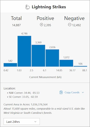
The Lightning Strikes feature let's you view and export strike counts. You can access the feature through the Lightning Strikes button in the upper right of the menu bar.
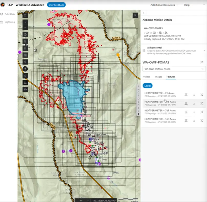
🔥Airborne Missions
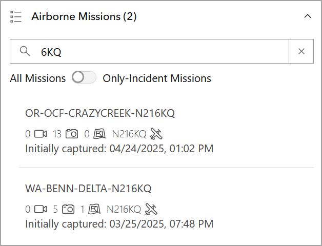
The Airborne Missions section has been added to the Incidents panel. The Airborne Missions section let's you search for missions as well as filter only incident missions.
Active Incidents: Incident Details
- Added accordions to the incident details.
- Added a checkbox to remove “No Value” entries.
Legend
- Added accordion to the map Legend.
U.I. enhancements
- Increased the width of the Layers menu for improved usability. -Updated the default basemap’s thumbnail to closer align with the map’s appearance.
- 🔥Minor Cartographic Symbol and Pop-up improvements to Aviation Services, DART Symbology by Apparatus Type, and FireGuard.
Bug Fixes
- Fixed an issue with swapping between 2D to 3D URLs.
- Fixed a scaling issue with overlapping U.I. on laptops.
- Fixed an issue with active incidents filters being hidden.
- 🔥Fixed an issue with the EGP Catalog filter tag scrolling.
Version 2.0.0 - Beta Release - May 1, 2025
Feature Updates
-
Incident Detail & Briefing Metrics Integration – Integrated Briefing Metrics & Incident Panel (right panel) to bring together the previous separate briefing concept into a single view. National and GACC Metrics updated every 5 minutes are added to the top of the right panel. Additionally, Search, Filter, List and see Incident Details in the Incident Panel. For a selected incident, there is now a One click “share” a direct link of the incident, lat/long, zoom, GACC, and even if in 2D or 3D mode. 🔥In WildFireSA Advanced, additional incident details are included on incident resources, operational notes, and ICS conditions detail
-
🔥Airborne Data available by Incident – In the same panel, for a selected incident, Airborne Intel is now grouped with active incidents for better organization and accessibility. Users can now directly see if an incident has airborne data within the incident card in the incident panel. (to see all missions in 1 list coming next sprint)
-
New UI changed to Grouped Layers and Add Data Experience – Common layers are now grouped for ease of use. A new “Add Data” interface (left panel) allows for quick adds of the EGP Curated data catalog, unique URLS, files or from other AGOL accounts can be easily added or removed (Save Session coming soon next).
-
Updated EGP Data Catalog – The WildFireSA Advanced “Add Data” widget is driven by the new EGP Data Hub Catalog. Linked from the portal, and requires a NIFC AGOL account to access, the EGP Curated data catalog of well over 100+ items includes improved metadata common with well-managed AGOL items.
-
Updated GIS Tool widgets included – New “black” tool buttons offer Simplified basic grouped layers with advanced “add Data” widget, dynamically updated legend, 3D mobile-friendly widget to replace legacy Fire Globe 3D application, an alpha Print widget, standard Measure tools, and a capability to drop and share Pins
-
Cartographically Designed Map Experience – To support the best view for Situational Awareness, stay informed, respond effectively to changing conditions, the modernized designed a new web map and grouped layers approach with 100s of feedback across over 60 web features services from dozens of wildland fire stakeholders (GISS, SITL, SIngle Resources, Dispatchers, more). This includes updates to symbology, labels, time refresh, grouping, transparency, pop-ups, and zoom levels ensure that users have the most accurate and easily interpretable data. Zoom changes the visible features to relevant data to provide that quick SA.
-
🔥WildFireSA Advanced Web Map brings Near Real-Time into Focus – This web map goes further to emphasize initial attack, emerging incidents, or when fires go on a run. The overall context is centered on near real-time data such as DART Resource Tracking, NIFS Operational Features, FireGuard Heat Detection, IAA Aircraft Intel, Weather Station Red Flag indicators and Active Incidents with rich pop-up content.
-
Web Maps are hosted and directly available via NIFC AGOL – All EGP Web Maps are now hosted on NIFC AGOL (access via Apps or directly with a NIFC AGOL account). The changes also allow for consuming a light WildFireSA WebMap version in Field Maps (Training to come).
-
User Feedback Form link – As this exciting update is rolled out, feedback from the fire user community is valuable to guide change and enhancement prioritization in data, features, and design (UI and Cartographic). The help page includes a feedback form to assist EGP with guidance on fine-tuning the features to best meet your needs.
Mid-May Release
Fixes and Enhancements coming – Overall 30 items for UI fixes are queued from feedback testing for UI improvements and minor fixes for:
- UI improvements Layer List, Briefing Metrics Display, and Incident Search Filtering
- Performance and Display limitations to the print tool and 3D Layers.
- 🔥Add Data panel add/remove fixes
- 🔥New AI Heat Detection service integration with PNNL RADR
- 🔥Airborne Intel Product features beta testing U.I. improvements
- New EGP FLIGHT application
Key Highlights in the Near-Term Backlog over the Spring/Summer 2025
An additional 100 improvements and updated prioritized features have been captured in a roadmap with feedback from stakeholders and coming during this period. Highlights:
- Further Data Catalog and WildFireSA Service Rationalization
- WildFireSA Mobile-Friendly improvements
- EGP and NIFC Camera Viewshed Coverage improvements
- Training on use of WildFireSA Web Maps in Field Maps and on the EGP Data Catalog
- Updated Resource Tracking Dashboard and Dynamic Metrics
- 🔥Personal View Save (Add/Remove Layers, GACC Region, re-open session)
- 🔥Automated Flight Following integration
- 🔥NIFC AGOL Login integration
- 🔥Further Airborne request IAA/NIROPS integration
- 🔥Improved Export Incident-centric Views.
- 🔥Airborne Missions without Incident View
- 🔥Lightning Explorer Tools Widget # Markdown syntax guide