An official website of the United States government.
Here's how you know.
Official websites use .gov
A .gov website belongs to an official government organization in the United States.
Secure .gov websites use HTTPS
A lock () or https:// means you've safely connected to the .gov website. Share sensitive information only on official, secure websites.
WildFireSA
The WildFireSA application is an integrated tactical and operational decision support tool used for wildland fires. WildFireSA combines a traditional "common operational picture" with collaborative mapping, geospatial and imagery analysis, and analytical reporting.
Open WildFireSA
Training Materials
FAQ
How can I access WildFireSA on my mobile device?
We recommend all mobile users access WildFireSA through the ArcGIS Field Maps application. For information on how to access and utilize Field Maps, please refer to the ArcGIS Field Maps Quick-Start Guide .
How can I share an incident?
You can share active incidents by selecting an incident from the Incidents panel, then selecting the Share button in the top right. The copied URL contains your current map view as well as the incident details.
Why is the layer I want to access greyed out and/or unable to be selected?
Some layers are available only at certain zoom levels. If your map view is zoomed out too far, the layer you wish to access may not be available. If this happens, adjust the zoom level until the layer becomes available.
The Data tab is missing. How can I get it back?
The Data tab is a feature of WildFireSA Advanced. Please sign in to WildFireSA Advanced.
Why is another mapping app or data source displaying information more quickly than WildFireSA?
WildFireSA is designed to pull data from multiple sources to provide the most comprehensive data available across all data sources. This means that we are working with some third-party sources that have a human component of data entry, therefore there is sometimes a delay in when we receive certain information. We are working closely with our third-party partners to continue to improve the speed, accuracy, and overall performance of the WildFireSA application.
Why is there a discrepancy between Active Incident Data and Perimeter Data?
Active Incidents and WFIGS location information is based on reported information gathered from multiple official sources, while WFIGS perimeter information is derived through spatial calculations. These datasets are intended to be used in tandem to paint a more complete picture of an active incident and are not meant to match exactly.
Why does my Layers Menu reset every time I access EGP? Is there a way to save my customizations?
After much feedback from our users requesting this functionality, we are currently working on a solution to allow you to save your Layers Menu customizations! Please stay tuned for more on this feature currently in development.
The layers I wish to enable aren’t showing up in the correct order/I cannot see one layer behind another.
To see all the selected layers, you may want to change the order of the layers or adjust the layer’s opacity so that one layer isn’t blocking another.
To adjust a layer’s opacity, select the layer’s Opacity button  and adjust the slider.
To rearrange layers, click and drag the Reposition
and adjust the slider.
To rearrange layers, click and drag the Reposition
 button.
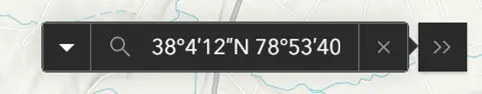
How can I search for a specific coordinates on the map?
You can adjust the latitude and longitude of the map by adjusting the information within the URL bar. You may also adjust the zoom level in the URL bar if you would like for the map to give you a closer view of your desired location.

Alternatively, you may enter the coordinates your desired coordinates into the search bar on the rightmost side of the map extent.
How do I export/download maps?
You can export maps by using the Print button from the map toolbar.
When I double-click an end spot using the Measure Tool it is not ending the measurement.
Please ensure when using the Measure Tool that your endpoint does not overlap with one of the other nodes that you have dropped. For example, if you dropped your first node, then a second and third and are ready to complete your measurement, select an endpoint that does not overlap with any of the previously dropped nodes.